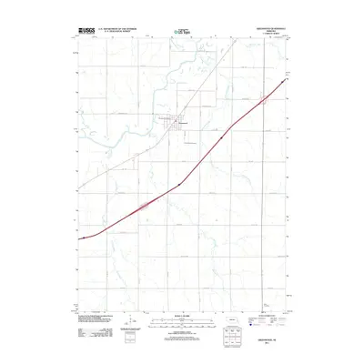
2011 Map of Greenwood
USGS Topo · Published 2011About this map
Greenwood sits at the heart of this Cass County landscape, defined by a dense network of meandering waterways that feed into the larger Salt Creek basin. The town's layout is closely tied to its historical infrastructure, centered around the Greenwood Post Office and a concentrated residential grid. Outside the central settlement, the terrain is partitioned by a strictly rectangular road system, including named corridors like Waverly Rd and Mynard Rd, which cross various tributaries such as Robinson Branch, Greenwood Creek, and Bee Creek. Genealogy interests are well-served by the inclusion of the Greenwood Cemetery just south of town and the Alvo Cemetery at the southern edge of the survey. The map illustrates a rural Nebraska community where the orderly lines of agricultural development intersect with the erratic, natural paths of Dee Creek and Camp Creek.
Find a feature on this map
29 named features on this map. Tap any name to fly to it.
Don’t see what you’re looking for? This feature index may not catch every label — zoom into the map to look around manually.
Map Details
Editions of this 2011 Greenwood Map
This is the sole edition of this map. No revisions or reprints were ever made.
Other maps of this area

1893 · Fremont
USGS Topo · 1:125,000

1896 · Fremont
USGS Topo · 1:125,000

1897 · Lincoln
USGS Topo · 1:125,000

1899 · Wahoo
USGS Topo · 1:125,000

1903 · Weeping Water
USGS Topo · 1:125,000

1929 · Weeping Water
USGS Topo · 1:125,000

1955 · Fremont
USGS Topo · 1:250,000

1955 · Lincoln
USGS Topo · 1:250,000

1957 · Fremont
USGS Topo · 1:250,000

1957 · Lincoln
USGS Topo · 1:250,000