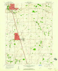
1959 Map of Greenwood
USGS Topo · Published 1960About this map
Greenwood and its southern neighbors show a pattern of mid-century suburban expansion along the Pennsylvania railroad corridor during the late 1950s. The emergence of New Whiteland and West Whiteland adjacent to the established center of Whiteland illustrates the era's residential development, while the surrounding landscape remains deeply tied to its agricultural roots. This rural character is defined by a dense network of drainage infrastructure, including Tracy Ditch, Graham Ditch, and Ransdell Run, essential for managing the fertile plains of Pleasant and Clark townships.
Find a feature on this map
49 named features on this map. Tap any name to fly to it.
Don’t see what you’re looking for? This feature index may not catch every label — zoom into the map to look around manually.
Map Details
Editions of this 1959 Greenwood Map
This is the sole edition of this map. No revisions or reprints were ever made.
Other maps of this area

1942 · Franklin
USGS Topo · 1:125,000

1942 · Columbus
USGS Topo · 1:125,000

1947 · Franklin
USGS Topo · 1:62,500

1948 · Franklin
USGS Topo · 1:24,000

1948 · Maywood
USGS Topo · 1:24,000

1948 · Beech Grove
USGS Topo · 1:24,000

1948 · Trafalgar
USGS Topo · 1:24,000

1948 · Marietta
USGS Topo · 1:24,000

1950 · Franklin
USGS Topo · 1:62,500

1950 · Edinburg
USGS Topo · 1:62,500