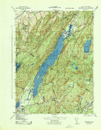
1943 Map of Greenwood Lake
USGS Topo · Published 1943About this map
The iron mining and processing heritage of the Highlands is clearly visible in this wartime survey, showing the Ringwood Iron Plant Mine and nearby Sterling Furnace. These industrial sites, alongside the Iron Plant near Lakeville, anchor a landscape where extraction met the growing recreational demands of the early 1940s. The elongated Greenwood Lake serves as the central focal point, straddling the border between New York and New Jersey, with the Greenwood Lake Water Supply infrastructure located at its northern tip. Dense residential and civic life is concentrated in pockets such as Warwick and West Milford, where local institutions like West Milford TWS School #4 and the Church of the Good Shepherd provided essential community services. The presence of the Erie Ringwood Branch railroad highlights the critical transportation network required to move heavy ore and passengers through the gaps between Bellvale Mountain and Bearfort Mountain.
Find a feature on this map
44 named features on this map. Tap any name to fly to it.
Don’t see what you’re looking for? This feature index may not catch every label — zoom into the map to look around manually.
Map Details
Editions of this 1943 Greenwood Lake Map
This is the sole edition of this map. No revisions or reprints were ever made.
Other maps of this area

1891 · Greenwood Lake
USGS Topo · 1:62,500

1891 · Ramapo
USGS Topo · 1:62,500

1893 · Greenwood Lake
USGS Topo · 1:62,500

1893 · Ramapo
USGS Topo · 1:62,500

1902 · Schunemunk
USGS Topo · 1:62,500

1903 · Greenwood Lake
USGS Topo · 1:62,500

1906 · Goshen
USGS Topo · 1:62,500

1908 · Goshen
USGS Topo · 1:62,500

1910 · Ramapo
USGS Topo · 1:62,500

1910 · Greenwood Lake
USGS Topo · 1:62,500