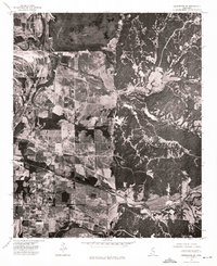
1974 Map of Greenwood SE
USGS Topo · Published 1975About this map
Browning sits at the edge of the Mississippi Delta, where the flat, agricultural bottomlands meet the rising bluffs of the Loess Hills. This 1974 orthophotograph captures a striking visual divide in the landscape: to the west, a strictly ordered grid of cultivated fields is interrupted only by the winding paths of drainage sloughs, while to the east, the terrain becomes a dense, shadowed network of wooded ridges and deep ravines. The settlement at Browning serves as a transition point between these two distinct geographies, situated near the foot of the hill line. The aerial imagery reveals the intense scale of land use in this portion of Carroll County during the mid-1970s, documenting every fence line, farm road, and clearing as they existed before decades of further reforestation and changing agricultural practices altered the rural pattern.
Find a feature on this map
1 named feature on this map. Tap any name to fly to it.
Don’t see what you’re looking for? This feature index may not catch every label — zoom into the map to look around manually.
Map Details
Editions of this 1974 Greenwood SE Map
This is the sole edition of this map. No revisions or reprints were ever made.
Other maps of this area

1936 · Greenwood
USGS Topo · 1:62,500

1940 · Seven Pines
USGS Topo · 1:62,500

1940 · Greenwood
USGS Topo · 1:62,500

1953 · Greenwood
USGS Topo · 1:250,000

1953 · West Point
USGS Topo · 1:250,000

1954 · McCarley
USGS Topo · 1:62,500

1956 · Greenwood
USGS Topo · 1:250,000

1957 · Greenwood
USGS Topo · 1:62,500

1957 · Seven Pines
USGS Topo · 1:62,500

1958 · West Point
USGS Topo · 1:250,000