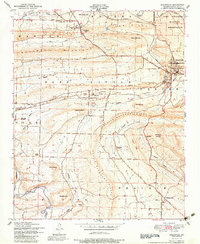
1951 Map of Greenwood
USGS Topo · Published 1983About this map
The ridge-and-valley terrain of Sebastian County is prominently displayed here during the mid-twentieth century, characterized by the industrial presence of multiple Strip mines near Excelsior and Adamson. The map documents a fascinating transition between settlements, clearly distinguishing between Old Jenny Lind and New Jenny Lind, the latter of which is anchored by the Jenny Lind Town Church and Jenny Lind School. Along the northern edge, the Camp Chaffee Military Reservation begins its eastward sprawl, while the rugged spine of Devils Backbone Ridge separates the central valley from the James Fork drainage to the south.
Find a feature on this map
44 named features on this map. Tap any name to fly to it.
Don’t see what you’re looking for? This feature index may not catch every label — zoom into the map to look around manually.
Map Details
Editions of this 1951 Greenwood Map
4 editions found
Other maps of this area

1879 · Fort Smith
USGS Topo · 1:62,500

1887 · Van Buren
USGS Topo · 1:62,500

1887 · Greenwood
USGS Topo · 1:62,500

1890 · Fort Smith
USGS Topo · 1:125,000

1906 · Lavaca
USGS Topo · 1:62,500

1906 · Barber
USGS Topo · 1:62,500

1943 · Fort Smith
USGS Topo · 1:125,000

1946 · Fort Smith
USGS Topo · 1:250,000

1947 · Lavaca
USGS Topo · 1:62,500

1947 · Van Buren
USGS Topo · 1:62,500