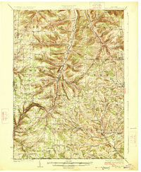
1926 Map of Greenwood
USGS Topo · Published 1926About this map
The New York and Pennsylvania RR snakes through the valley of Bennett Creek, connecting the rural hamlets of Bennetts, Greenwood, and Rexville in this mid-1920s survey. The landscape is defined by its dense network of district schools and local landmarks, from the Catholic Church School to the West Union Grange Hall. Settlement patterns follow the deep hollows and creek beds, with isolated communities like Rough and Ready and Alice established near the Pennsylvania border. Notable family-named terrain and institutions, such as Colonel Bill's Hill and Barney Mills, illustrate the ingrained local history of Steuben County. The infrastructure of the era is evident along State Highway No 17, while the higher elevations of Green Hill and Marsh Hill overlook a patchwork of small farms and parish churches like Spring Brook Church.
Find a feature on this map
104 named features on this map. Tap any name to fly to it.
Don’t see what you’re looking for? This feature index may not catch every label — zoom into the map to look around manually.
Map Details
Editions of this 1926 Greenwood Map
4 editions found

Other maps of this area

1899 · Gaines
USGS Topo · 1:62,500

1900 · Gaines
USGS Topo · 1:62,500

1900 · Elkland
USGS Topo · 1:62,500

1910 · Bath
USGS Topo · 1:62,500

1915 · Hornell
USGS Topo · 1:62,500

1916 · Canaseraga
USGS Topo · 1:62,500

1918 · Hornell
USGS Topo · 1:62,500

1924 · Woodhull
USGS Topo · 1:48,000

1926 · Wellsville
USGS Topo · 1:62,500

1926 · Woodhull
USGS Topo · 1:62,500