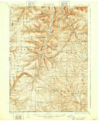
1926 Map of Greenwood
USGS Topo · Published 1932About this map
Greenwood and the surrounding townships of Troupsburg and West Union define this rural Steuben County landscape during the mid-1920s. The region is characterized by a dense network of district education, with dozens of institutions like Putman School, Whiteman School, and McGraw School serving the farming families scattered across the hills. The New York and Pennsylvania RR provides a critical industrial corridor through the valley, tracing the path of Bennett Creek past the settlement of Rexville and the industrial outpost at Barney Mills.
Find a feature on this map
100 named features on this map. Tap any name to fly to it.
Don’t see what you’re looking for? This feature index may not catch every label — zoom into the map to look around manually.
Map Details
Editions of this 1926 Greenwood Map
4 editions found

Other maps of this area

1899 · Gaines
USGS Topo · 1:62,500

1900 · Gaines
USGS Topo · 1:62,500

1900 · Elkland
USGS Topo · 1:62,500

1910 · Bath
USGS Topo · 1:62,500

1915 · Hornell
USGS Topo · 1:62,500

1916 · Canaseraga
USGS Topo · 1:62,500

1918 · Hornell
USGS Topo · 1:62,500

1924 · Woodhull
USGS Topo · 1:48,000

1926 · Wellsville
USGS Topo · 1:62,500

1926 · Woodhull
USGS Topo · 1:62,500