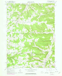
1978 Map of Greenwood
USGS Topo · Published 1978About this map
Greenwood and its surrounding hollows define the landscape of this Steuben County corner during the late 1970s. The settlement pattern is largely dictated by the complex drainage of Bennetts Creek and Canisteo Creek, where steep ridges like Hartsville Hill and Call Hill separate small farming and energy-producing communities. This era reveals a significant footprint of the local petroleum industry, with clusters of Oil Wells and Gas Wells appearing throughout the terrain, supported by a Pipeline and a Compressor Station.
Find a feature on this map
57 named features on this map. Tap any name to fly to it.
Don’t see what you’re looking for? This feature index may not catch every label — zoom into the map to look around manually.
Map Details
Editions of this 1978 Greenwood Map
This is the sole edition of this map. No revisions or reprints were ever made.
Other maps of this area

1915 · Hornell
USGS Topo · 1:62,500

1916 · Canaseraga
USGS Topo · 1:62,500

1918 · Hornell
USGS Topo · 1:62,500

1926 · Wellsville
USGS Topo · 1:62,500

1926 · Greenwood
USGS Topo · 1:62,500

1940 · Canaseraga
USGS Topo · 1:62,500

1950 · Elmira
USGS Topo · 1:250,000

1954 · South Canisteo
USGS Topo · 1:24,000

1954 · Troupsburg
USGS Topo · 1:24,000
1954 · Canisteo
USGS Topo · 1:24,000