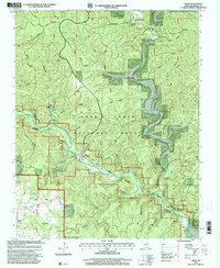
1997 Map of Greer
USGS Topo · Published 2000About this map
The Eleven Point River carves a deep path through the heart of the Mark Twain National Forest, anchoring a landscape defined by its karst hydrology and historic river-dependent settlements. This late-twentieth-century survey reveals the enduring character of the Ozarks, where massive springs like Greer Spring and Falling Spring feed the river system. Along the river banks, the presence of Turners Mill and nearby Mary Deckard Shoals points to the area's history of water-powered industry and river navigation. Local family history is preserved in small upland clearings containing the Saints Cemetery, Hall Cemetery, and Russ Cemetery, often located near crossroads such as Greer or gathering places like the Oak Forest Church. The map traces a network of hollows—including Mine Hollow and Duncan Hollow—that run toward the main channel, illustrating the complex drainage patterns of the Oregon County terrain.
Find a feature on this map
60 named features on this map. Tap any name to fly to it.
Don’t see what you’re looking for? This feature index may not catch every label — zoom into the map to look around manually.
Map Details
Editions of this 1997 Greer Map
This is the sole edition of this map. No revisions or reprints were ever made.
Other maps of this area

1931 · Bandyville
USGS Topo · 1:48,000

1941 · Gatewood
USGS Topo · 1:62,500

1944 · Van Buren
USGS Topo · 1:62,500

1944 · Couch
USGS Topo · 1:62,500

1944 · Birch Tree
USGS Topo · 1:62,500

1945 · Gatewood
USGS Topo · 1:62,500

1946 · Couch
USGS Topo · 1:62,500

1946 · Van Buren
USGS Topo · 1:62,500

1948 · Birch Tree
USGS Topo · 1:62,500

1957 · Poplar Bluff
USGS Topo · 1:250,000