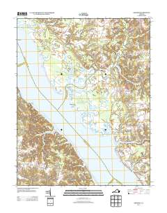
2013 Map of Gressitt
USGS Topo · Published 2013About this map
The York River dominates this Tidewater landscape, where the confluence with the Poropotank River creates a complex network of marshes and inlets. Along the eastern shore, maritime activity is centered at Allmonds Wharf and the nearby settlement of Allmondsville, while the Bell Rock Lighthouse stands watch over the upper river reach. The interior of Gloucester and King and Queen Counties is marked by small crossroads communities like Signpine and Plain View, which are connected by historic routes such as Buena Vista Rd and York River Rd.
Find a feature on this map
39 named features on this map. Tap any name to fly to it.
Don’t see what you’re looking for? This feature index may not catch every label — zoom into the map to look around manually.
Map Details
Editions of this 2013 Gressitt Map
This is the sole edition of this map. No revisions or reprints were ever made.
Other maps of this area

1906 · Williamsburg
USGS Topo · 1:62,500

1917 · Urbanna
USGS Topo · 1:62,500

1917 · Toano
USGS Topo · 1:62,500

1918 · Toano
USGS Topo · 1:62,500

1919 · New Kent
USGS Topo · 1:62,500

1943 · Richmond
USGS Topo · 1:250,000
1949 · Saluda
USGS Topo · 1:24,000

1949 · Shacklefords
USGS Topo · 1:24,000

1949 · Richmond
USGS Topo · 1:250,000

1950 · West Point
USGS Topo · 1:24,000