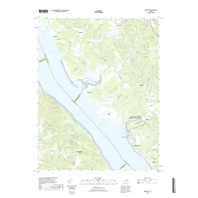
2019 Map of Gressitt
USGS Topo · Published 2019About this map
The York River serves as the dominant geographical feature of this coastal Virginia landscape, acting as a historical boundary between Gloucester, James City, and King and Queen counties. Following the northern shoreline, the Captain John Smith National Historic Trail traces the colonial heritage of the region, passing through diverse wetlands and tidal inlets. The map illustrates a network of established settlements such as Plain View, Gressitt, and Signpine, which are connected by historic routes like the Chipun Path.
Find a feature on this map
125 named features on this map. Tap any name to fly to it.
Don’t see what you’re looking for? This feature index may not catch every label — zoom into the map to look around manually.
Map Details
Editions of this 2019 Gressitt Map
This is the sole edition of this map. No revisions or reprints were ever made.
Other maps of this area

1906 · Williamsburg
USGS Topo · 1:62,500

1917 · Urbanna
USGS Topo · 1:62,500

1917 · Toano
USGS Topo · 1:62,500

1918 · Toano
USGS Topo · 1:62,500

1919 · New Kent
USGS Topo · 1:62,500

1943 · Richmond
USGS Topo · 1:250,000
1949 · Saluda
USGS Topo · 1:24,000

1949 · Shacklefords
USGS Topo · 1:24,000

1949 · Richmond
USGS Topo · 1:250,000

1950 · West Point
USGS Topo · 1:24,000