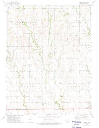
1973 Map of Gretna
USGS Topo · Published 1975About this map
The Chicago Rock Island and Pacific railroad forms the southern backbone of this rural landscape, connecting the small settlements of Gretna and Agra. The area is defined by the drainage basins of several prominent waterways, including Big Creek to the west and the various branches of Plum Creek which carve through the central townships of Arcade and Plum. These creek valleys dictate the placement of local infrastructure, from the winding dirt roads to the secluded Plum Creek Church.
Find a feature on this map
21 named features on this map. Tap any name to fly to it.
Don’t see what you’re looking for? This feature index may not catch every label — zoom into the map to look around manually.
Map Details
Editions of this 1973 Gretna Map
This is the sole edition of this map. No revisions or reprints were ever made.
Other maps of this area

1893 · Phillipsburg
USGS Topo · 1:125,000

1955 · Beloit
USGS Topo · 1:250,000

1959 · Beloit
USGS Topo · 1:250,000

1972 · Kirwin
USGS Topo · 1:24,000

1972 · Kirwin Reservoir
USGS Topo · 1:24,000

1972 · Phillipsburg South
USGS Topo · 1:24,000

1973 · Kensington
USGS Topo · 1:24,000

1973 · Kensington NE
USGS Topo · 1:24,000

1973 · Stuttgart NE
USGS Topo · 1:24,000
1973 · Kensington NW
USGS Topo · 1:24,000