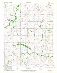
1967 Map of Gridley NW
USGS Topo · Published 1968About this map
The rolling grasslands at the junction of Lyon, Coffey, and Greenwood counties are defined by the rural townships of Elmendaro, Pleasant, Shell Rock, and Liberty. This mid-1960s landscape shows a transition between traditional agriculture and modern industrial utility, as evidenced by a prominent Pipeline cutting across the terrain and scattered Oil Wells and a Drill Hole in the northern sections.
Find a feature on this map
16 named features on this map. Tap any name to fly to it.
Don’t see what you’re looking for? This feature index may not catch every label — zoom into the map to look around manually.
Map Details
Editions of this 1967 Gridley NW Map
This is the sole edition of this map. No revisions or reprints were ever made.
Other maps of this area

1885 · Burlington
USGS Topo · 1:125,000

1888 · Emporia
USGS Topo · 1:125,000

1894 · Emporia
USGS Topo · 1:125,000

1894 · Burlington
USGS Topo · 1:125,000

1947 · Lawrence
USGS Topo · 1:250,000

1950 · Lawrence
USGS Topo · 1:250,000

1955 · Hutchinson
USGS Topo · 1:250,000

1956 · Lawrence
USGS Topo · 1:250,000

1959 · Hutchinson
USGS Topo · 1:250,000

1961 · Lawrence
USGS Topo · 1:250,000