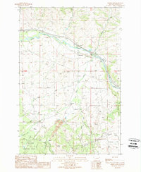
1989 Map of Griffin Creek
USGS Topo · Published 1989About this map
Goldcreek and the mining-scarred landscape of Wall City define this portion of the Clark Fork valley in the late twentieth century. The map illustrates a complex history of resource extraction, with multiple prospects, a gravel pit, and extensive tailings deposits concentrated near Pikes Peak Gulch and Pioneer Gulch. These industrial signatures contrast with the protected lands of the Deerlodge National Forest to the southwest, where the terrain rises sharply toward Pikes Peak.
Find a feature on this map
36 named features on this map. Tap any name to fly to it.
Don’t see what you’re looking for? This feature index may not catch every label — zoom into the map to look around manually.
Map Details
Editions of this 1989 Griffin Creek Map
This is the sole edition of this map. No revisions or reprints were ever made.
Other maps of this area

1889 · Helena
USGS Topo · 1:250,000

1893 · Helena
USGS Topo · 1:250,000

1899 · Helena
USGS Topo · 1:250,000

1903 · Helena
USGS Topo · 1:250,000

1908 · Philipsburg
USGS Topo · 1:125,000

1919 · Drummond
USGS Topo · 1:125,000

1921 · Drummond
USGS Topo · 1:125,000

1947 · Butte
USGS Topo · 1:250,000

1958 · Butte
USGS Topo · 1:250,000

1958 · Drummond
USGS Topo · 1:62,500