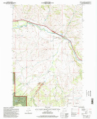
1996 Map of Griffin Creek
USGS Topo · Published 1998About this map
Goldcreek and the northern reaches of the Montana State Prison Ranch dominate this mid-1990s terrain. The Clark Fork winds through the northern portion of the quadrangle, flanked by industrial and utility markers including a Gaging Sta, Substation, and a Comm Facility. This landscape is heavily shaped by both state jurisdiction and resource extraction, with the Deerlodge National Forest boundary intersecting a network of drainage systems such as Griffin Creek and Blum Creek. Evidence of historical and active mineral exploration is visible through numerous Prospects and Tailings piles located near Wall City and along the slopes of Gold Hill. The southern portion of the map is defined by steep draws like Pioneer Gulch, Squaw Gulch, and French Gulch, illustrating the transition from the river valley to the more rugged interior.
Find a feature on this map
30 named features on this map. Tap any name to fly to it.
Don’t see what you’re looking for? This feature index may not catch every label — zoom into the map to look around manually.
Map Details
Editions of this 1996 Griffin Creek Map
This is the sole edition of this map. No revisions or reprints were ever made.
Other maps of this area

1889 · Helena
USGS Topo · 1:250,000

1893 · Helena
USGS Topo · 1:250,000

1899 · Helena
USGS Topo · 1:250,000

1903 · Helena
USGS Topo · 1:250,000

1908 · Philipsburg
USGS Topo · 1:125,000

1919 · Drummond
USGS Topo · 1:125,000

1921 · Drummond
USGS Topo · 1:125,000

1947 · Butte
USGS Topo · 1:250,000

1958 · Butte
USGS Topo · 1:250,000

1958 · Drummond
USGS Topo · 1:62,500