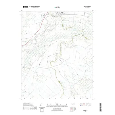
2019 Map of Grifton
USGS Topo · Published 2019About this map
Grifton sits at the confluence of the Neuse River and Contentnea Creek, anchoring a landscape defined by the intricate hydrology of the coastal plain. This 2019 survey captures the transition from the town center to the surrounding wetlands and agricultural tracts, where names like Eagle Swamp and Jacks Slough reflect the low-lying character of the terrain. The map details a complex network of artificial drainage systems, including the Alligator Canal, Rhem Canal, and Buckleberry Canal, which have historically managed the water table for timber and farming. Local landmarks such as Oak Bridge and Clark Field appear alongside the smaller settlement of Closs, illustrating the dispersed residential patterns between the river bends and creek bottoms. The presence of numerous named branches, such as Bone Gray Br and Harrys Br, highlights the fine-grained water network that dictates land use across this portion of Lenoir and Pitt counties.
Find a feature on this map
88 named features on this map. Tap any name to fly to it.
Don’t see what you’re looking for? This feature index may not catch every label — zoom into the map to look around manually.
Map Details
Editions of this 2019 Grifton Map
This is the sole edition of this map. No revisions or reprints were ever made.
Other maps of this area

1902 · Ayden
USGS Topo · 1:62,500

1903 · Trent River
USGS Topo · 1:62,500

1904 · Ayden
USGS Topo · 1:62,500

1904 · Trent River
USGS Topo · 1:62,500

1914 · Kinston
USGS Topo · 1:48,000

1916 · Kinston
USGS Topo · 1:62,500

1953 · Rocky Mount
USGS Topo · 1:250,000

1954 · Rocky Mount
USGS Topo · 1:250,000

1958 · Deep Run
USGS Topo · 1:62,500
1980 · Rivermont
USGS Topo · 1:24,000