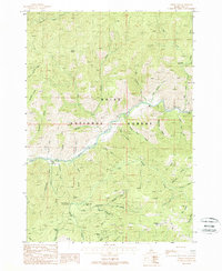
1988 Map of Grimes Pass
USGS Topo · Published 1989About this map
The rugged drainage of the South Fork Payette River and its numerous tributaries dominate this 1980s landscape in the Boise National Forest. The map centers on the high-elevation crossing of Grimes Pass, a location of significant local lore as noted by the Grimes Monument. This region reflects a long history of resource extraction, with multiple mining operations scattered across the steep gulches, including the Golden Age Mine, the Missouri Mine, and the Comeback Mine. The terrain is deeply incised by a complex network of waterways like Anderson Creek and Grimes Creek, while the presence of Basque Spring alludes to the historic sheep-herding traditions of the Idaho backcountry. Researchers will find a land defined by its mining claims and remote mountain peaks, such as the 7,351-foot Jackson Peak, served by a winding system of forest roads and trails.
Find a feature on this map
46 named features on this map. Tap any name to fly to it.
Don’t see what you’re looking for? This feature index may not catch every label — zoom into the map to look around manually.
Map Details
Editions of this 1988 Grimes Pass Map
This is the sole edition of this map. No revisions or reprints were ever made.
Other maps of this area

1894 · Idaho Basin
USGS Topo · 1:125,000

1909 · Garden Valley
USGS Topo · 1:125,000

1955 · Hailey
USGS Topo · 1:250,000

1957 · Placerville
USGS Topo · 1:24,000

1957 · Pioneerville
USGS Topo · 1:24,000

1957 · Challis
USGS Topo · 1:250,000

1959 · Hailey
USGS Topo · 1:250,000

1959 · Garden Valley
USGS Topo · 1:62,500

1960 · Challis
USGS Topo · 1:250,000

1962 · Hailey
USGS Topo · 1:250,000