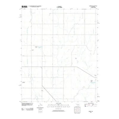
2010 Map of Grimes
USGS Topo · Published 2010About this map
Brookside Cemetery, Buffalo Cemetery, and Wayland Cemetery anchor this rural Roger Mills County landscape, providing essential points of reference for genealogists tracing family roots in western Oklahoma. The terrain is defined by the branching drainage systems of Middle Buffalo Creek and Starvation Creek, where numerous small-scale water management projects are visible. Named landmarks like the Shirley Thompson Dam and Fuchs Dam indicate a reliance on localized reservoirs, such as the Shirley Thompson Reservoir, to support the agricultural needs of the region. The map also records the exact positioning of the McLaury Number 2 Reservoir and the Oknoname 129009 Dam, reflecting the land use patterns and water infrastructure necessary for Oklahoma's high plains ranching and farming operations during this era.
Find a feature on this map
14 named features on this map. Tap any name to fly to it.
Don’t see what you’re looking for? This feature index may not catch every label — zoom into the map to look around manually.
Map Details
Editions of this 2010 Grimes Map
This is the sole edition of this map. No revisions or reprints were ever made.
Other maps of this area

1955 · Clinton
USGS Topo · 1:250,000

1957 · Clinton
USGS Topo · 1:250,000

1960 · Sweetwater
USGS Topo · 1:62,500

1960 · Cheyenne
USGS Topo · 1:62,500

1960 · Sayre
USGS Topo · 1:62,500

1961 · Reydon
USGS Topo · 1:62,500

1984 · Foss Reservoir
USGS Topo · 1:100,000

1985 · Elk City
USGS Topo · 1:100,000
1988 · Grimes
USGS Topo · 1:24,000

1988 · Dempsey
USGS Topo · 1:24,000