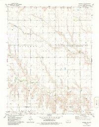
1979 Map of Grinnell NE
USGS Topo · Published 1986About this map
The Saline River cuts across this High Plains landscape, marking a central drainage point in Sheridan County. To the north, Spring Brook and its tributary Spring Brook Creek define the upper terrain, while the southern edge of the map follows the Sheridan Co Gove Co line. This survey, based on mid-1970s photography, documents a landscape shaped by both water and rail transportation. Along the southern border, the Union Pacific railroad corridor passes through the northern reaches of Grinnell and Grainfield, illustrating the importance of this transit line to the region's agricultural economy. Pockets of industry are evident through several Sandpits and a Gravel Pit, providing insight into local resource extraction along the North Fork Big Creek and the river valley during the late twentieth century.
Find a feature on this map
11 named features on this map. Tap any name to fly to it.
Don’t see what you’re looking for? This feature index may not catch every label — zoom into the map to look around manually.
Map Details
Editions of this 1979 Grinnell NE Map
2 editions found
Other maps of this area

1954 · Goodland
USGS Topo · 1:250,000

1956 · Goodland
USGS Topo · 1:250,000

1957 · Goodland
USGS Topo · 1:250,000

1979 · Menlo
USGS Topo · 1:24,000

1979 · Midway Draw West
USGS Topo · 1:24,000
1979 · Grainfield
USGS Topo · 1:24,000

1979 · Hoxie
USGS Topo · 1:24,000
1979 · Grinnell South
USGS Topo · 1:24,000

1979 · Grinnell NE
USGS Topo · 1:24,000
1979 · Sunny Slope Lake
USGS Topo · 1:24,000