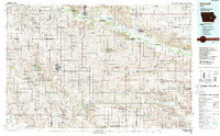
1984 Map of Grinnell
USGS Topo · Published 1989About this map
The Sac and Fox Indian Reservation lies along the Iowa River north of Tama, anchoring the northern portion of this East Central Iowa landscape. In the mid-1980s, the region was defined by a grid of agricultural townships and the persistent presence of the Chicago and North Western railroad, which links historic prairie settlements from Grinnell to Belle Plaine. The topography is shaped by the drainage systems of the North Skunk River and English River, while dedicated conservation areas like the Otter Creek Marsh State Wildlife Refuge and Rock Creek State Park provide contrast to the surrounding farmland. Numerous small airfields, including Grinnell Airport and several private landing strips like Hawkins Landing Strip, suggest the vital role of general aviation in this rural economy during the late twentieth century.
Find a feature on this map
141 named features on this map. Tap any name to fly to it.
Don’t see what you’re looking for? This feature index may not catch every label — zoom into the map to look around manually.
Map Details
Editions of this 1984 Grinnell Map
2 editions found
Other maps of this area

1888 · Shellsburg
USGS Topo · 1:62,500

1888 · Amana
USGS Topo · 1:62,500

1889 · Amana
USGS Topo · 1:62,500

1889 · Shellsburg
USGS Topo · 1:62,500

1891 · Oxford
USGS Topo · 1:62,500

1894 · Oxford
USGS Topo · 1:62,500

1899 · Amana
USGS Topo · 1:62,500

1899 · Shellsburg
USGS Topo · 1:62,500

1903 · Fairfax
USGS Topo · 1:125,000

1903 · Winthrop
USGS Topo · 1:125,000