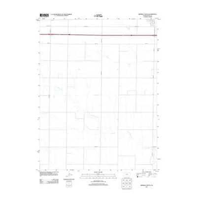
2012 Map of Grinnell South
USGS Topo · Published 2012About this map
Campus sits at the northern edge of this Gove County landscape, a small settlement area just off the historic path of Old Hwy 40. The terrain is defined by the drainage patterns of the High Plains, where the headwaters and tributaries of Big Cr and N Br Hackberry Cr carve subtle incisions across the agricultural grid. This 2012 survey illustrates a modern rural infrastructure of section-line roads such as Angles Rd, Campas Rd, and Gove CC, which connect the isolated farmsteads typical of western Kansas. The map captures the transit corridor where Interstate 70 runs parallel to the older highway and the local street grid of Grinnell, including Oak St and S 2nd, providing a clear view of the intersection between historic overland routes and contemporary regional transportation.
Find a feature on this map
12 named features on this map. Tap any name to fly to it.
Don’t see what you’re looking for? This feature index may not catch every label — zoom into the map to look around manually.
Map Details
Editions of this 2012 Grinnell South Map
This is the sole edition of this map. No revisions or reprints were ever made.
Other maps of this area

1954 · Goodland
USGS Topo · 1:250,000

1955 · Scott City
USGS Topo · 1:250,000

1956 · Goodland
USGS Topo · 1:250,000

1957 · Goodland
USGS Topo · 1:250,000

1958 · Scott City
USGS Topo · 1:250,000

1972 · Orion NE
USGS Topo · 1:24,000

1972 · Orion
USGS Topo · 1:24,000

1972 · Elkader NE
USGS Topo · 1:24,000
1979 · Oakley South
USGS Topo · 1:24,000
1979 · Grinnell South
USGS Topo · 1:24,000