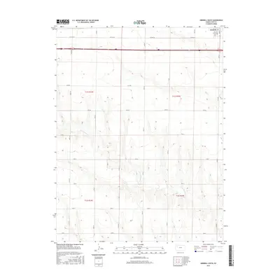
2015 Map of Grinnell South
USGS Topo · Published 2015About this map
Grinnell sits at the northern edge of this high plains landscape in Gove County, where the transition from a gridded townsite to the expansive ranch and farmland of western Kansas is clearly defined. The terrain is marked by the subtle drainage patterns of Big Cr and the N Br Hackberry Cr, which carve shallow draws through the prairie. Modern infrastructure dominates the northern corridor, including the historic path of Old Hwy 40 and a network of county roads like Campas Rd and Co Rd 18 that maintain the strict Public Land Survey System boundaries.
Find a feature on this map
30 named features on this map. Tap any name to fly to it.
Don’t see what you’re looking for? This feature index may not catch every label — zoom into the map to look around manually.
Map Details
Editions of this 2015 Grinnell South Map
This is the sole edition of this map. No revisions or reprints were ever made.
Other maps of this area
1954 · Goodland
USGS Topo · 1:250,000
1955 · Scott City
USGS Topo · 1:250,000
1956 · Goodland
USGS Topo · 1:250,000
1957 · Goodland
USGS Topo · 1:250,000
1958 · Scott City
USGS Topo · 1:250,000
1972 · Orion NE
USGS Topo · 1:24,000
1972 · Orion
USGS Topo · 1:24,000
1972 · Elkader NE
USGS Topo · 1:24,000
1979 · Oakley South
USGS Topo · 1:24,000
1979 · Grinnell South
USGS Topo · 1:24,000