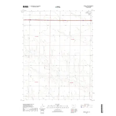
2018 Map of Grinnell South
USGS Topo · Published 2018About this map
Grinnell sits at the northern edge of this Gove County landscape, where the residential grid meets the open plains of western Kansas. The survey reveals a terrain defined by the drainage patterns of Big Cr and the branching reaches of N Br Hackberry Cr, which carve subtle coulees through the high prairie. Transportation history is visible in the corridor of Old Hwy 40, running parallel to the modern interstate and the township lines of t11s r31w and t11s r30w. The map preserves the specific local nomenclature of the rural road network, including Grove Cc and Campas Rd, which provide a detailed look at the section-line layout that dictates the region's agricultural geography. In the town of Grinnell itself, street-level details like Jefferson St and S Adams St offer precise landmarks for local history research.
Find a feature on this map
21 named features on this map. Tap any name to fly to it.
Don’t see what you’re looking for? This feature index may not catch every label — zoom into the map to look around manually.
Map Details
Editions of this 2018 Grinnell South Map
This is the sole edition of this map. No revisions or reprints were ever made.
Other maps of this area

1954 · Goodland
USGS Topo · 1:250,000

1955 · Scott City
USGS Topo · 1:250,000

1956 · Goodland
USGS Topo · 1:250,000

1957 · Goodland
USGS Topo · 1:250,000

1958 · Scott City
USGS Topo · 1:250,000

1972 · Orion NE
USGS Topo · 1:24,000

1972 · Orion
USGS Topo · 1:24,000

1972 · Elkader NE
USGS Topo · 1:24,000
1979 · Oakley South
USGS Topo · 1:24,000
1979 · Grinnell South
USGS Topo · 1:24,000