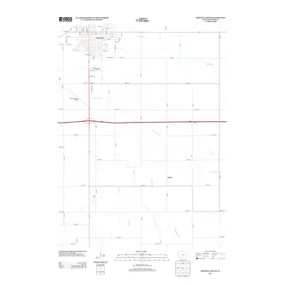
2013 Map of Grinnell South
USGS Topo · Published 2013About this map
Grinnell serves as the primary urban hub on this Iowa prairie landscape, with its southern residential and industrial extensions reaching toward the intersection of state and federal transit corridors. The street grid is well-defined by local thoroughfares such as Main St and Elm St, which lead south past the Poweshiek County Fairgrounds. Beyond the town limits, the land transitions into a systematic agricultural pattern of section-line roads like Ewart Rd and Walnut Rd. Hydrological features including the N English River, English Cr, and Middle Buck Cr cut through the farming tracts, providing a natural contrast to the rigid road geometry. The map also documents outlying community points like Oak Grove and Jacobs, which reflect the distributed settlement history of the region south of the Grinnell Regional Airport.
Find a feature on this map
66 named features on this map. Tap any name to fly to it.
Don’t see what you’re looking for? This feature index may not catch every label — zoom into the map to look around manually.
Map Details
Editions of this 2013 Grinnell South Map
This is the sole edition of this map. No revisions or reprints were ever made.
Other maps of this area

1954 · Des Moines
USGS Topo · 1:250,000

1956 · Des Moines
USGS Topo · 1:250,000

1957 · Des Moines
USGS Topo · 1:250,000

1969 · Des Moines
USGS Topo · 1:250,000

1979 · Montezuma
USGS Topo · 1:24,000

1979 · Searsboro
USGS Topo · 1:24,000

1979 · Grinnell South
USGS Topo · 1:24,000
1979 · Malcom
USGS Topo · 1:24,000

1980 · Newburg
USGS Topo · 1:24,000

1980 · Sully
USGS Topo · 1:24,000