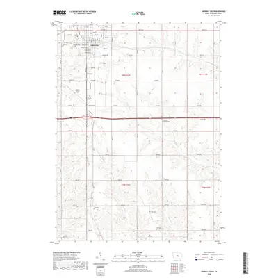
2018 Map of Grinnell South
USGS Topo · Published 2018About this map
The southern outskirts of Grinnell give way to a structured grid of rural townships and winding waterways in this late-2010s survey. The landscape is defined by the headwaters of several streams, including the N English River, English Cr, and Middle Buck Cr, which carve subtle drainages through the agricultural terrain. The map captures the transition from the city's residential and industrial streets, such as Industrial Ave and Hamilton Ave, to the broader county road network south of the Grinnell Regional Airport.
Find a feature on this map
80 named features on this map. Tap any name to fly to it.
Don’t see what you’re looking for? This feature index may not catch every label — zoom into the map to look around manually.
Map Details
Editions of this 2018 Grinnell South Map
This is the sole edition of this map. No revisions or reprints were ever made.
Other maps of this area

1954 · Des Moines
USGS Topo · 1:250,000

1956 · Des Moines
USGS Topo · 1:250,000

1957 · Des Moines
USGS Topo · 1:250,000

1969 · Des Moines
USGS Topo · 1:250,000

1979 · Montezuma
USGS Topo · 1:24,000

1979 · Searsboro
USGS Topo · 1:24,000

1979 · Grinnell South
USGS Topo · 1:24,000
1979 · Malcom
USGS Topo · 1:24,000

1980 · Newburg
USGS Topo · 1:24,000

1980 · Sully
USGS Topo · 1:24,000