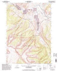
1996 Map of Grizzly Lake
USGS Topo · Published 1998About this map
Red Rock Ranch sits along the Crystal Creek drainage, serving as a rare point of human settlement in this high-altitude landscape. This 1990s-era topography reveals a transition between the Teton National Forest and the protected lands of the Gros Ventre Wilderness, where the Gros Ventre River carves through the Red Hills. The map provides specific detail on the hydraulic patterns of the region, including several 4wd tracks and the Ditch near the river bend. Geologic and topographic features like Grizzly Lake, Hidden Basin, and Haystack peaks dominate the southern and eastern quadrants. The mapping reflects a late 20th-century view of Wyoming's backcountry, capturing the intricate drainage systems of Slate Creek and Redmond Creek before modern environmental shifts or expanded recreational access changed the character of these remote reaches.
Find a feature on this map
24 named features on this map. Tap any name to fly to it.
Don’t see what you’re looking for? This feature index may not catch every label — zoom into the map to look around manually.
Map Details
Editions of this 1996 Grizzly Lake Map
This is the sole edition of this map. No revisions or reprints were ever made.
Other maps of this area

1899 · Grand Teton
USGS Topo · 1:125,000

1901 · Grand Teton
USGS Topo · 1:125,000
1902 · Mt Leidy
USGS Topo · 1:125,000

1907 · Gros Ventre
USGS Topo · 1:125,000

1910 · Gros Ventre
USGS Topo · 1:125,000

1931 · Jackson
USGS Topo · 1:125,000

1935 · Jackson
USGS Topo · 1:125,000

1955 · Driggs
USGS Topo · 1:250,000

1958 · Driggs
USGS Topo · 1:250,000

1962 · Driggs
USGS Topo · 1:250,000