
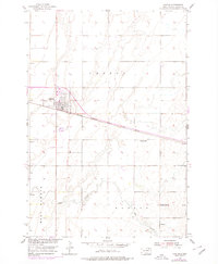
1954 Map of Groton
USGS Topo · Published 1955About this map
Groton serves as the central hub of this agricultural landscape in the mid-1950s, defined by the intersection of major transportation corridors. The town's grid is situated just north of the Chicago Milwaukee St Paul and Pacific railroad, while the Chicago and North Western tracks run north-south nearby. Outside the town limits, the landscape transitions into the open plains of Groton and West Hanson townships, where rural life is anchored by landmarks such as the Prairie Side Sch and the Groton Cem. Water management and the prairie environment are evident through features like the Flowing Well, a Windmill, and the winding path of Mud Creek to the south. This survey was produced as part of a Department of the Interior program focused on the development of the Missouri River Basin, reflecting the era's emphasis on systematic land use and water resource planning.
Find a feature on this map
10 named features on this map. Tap any name to fly to it.
Don’t see what you’re looking for? This feature index may not catch every label — zoom into the map to look around manually.
Map Details
Editions of this 1954 Groton Map
2 editions found
Other maps of this area

1895 · Aberdeen
USGS Topo · 1:125,000

1896 · Columbia
USGS Topo · 1:125,000

1952 · Huffton
USGS Topo · 1:24,000

1952 · Putney
USGS Topo · 1:24,000

1953 · Groton SW
USGS Topo · 1:24,000

1953 · Milbank
USGS Topo · 1:250,000

1954 · James
USGS Topo · 1:24,000

1954 · Ferney
USGS Topo · 1:24,000

1954 · Aberdeen
USGS Topo · 1:250,000

1956 · Aberdeen
USGS Topo · 1:250,000