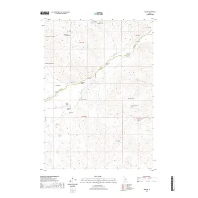
2020 Map of Grouse
USGS Topo · Published 2020About this map
Lost River and the small settlement of Grouse occupy a high mountain valley where the Custer and Butte County line divides the landscape. This high-altitude drainage is defined by the White Knob Mountains to the north and numerous steep-walled corridors like Waddoups Canyon, Schoolhouse Canyon, and Graveyard Canyon. The map reveals a land shaped by water and aviation, featuring the Antelope Valley Airport and a network of named springs including Mountain Spring and Richardson Spring. Local history is anchored at the Antelope Cemetery and the grazing lands of Antelope Valley, where roads like Antelope Road and Cherry Creek Road follow the natural contours of the valley floor between peaks such as Black Cap Peak.
Find a feature on this map
42 named features on this map. Tap any name to fly to it.
Don’t see what you’re looking for? This feature index may not catch every label — zoom into the map to look around manually.
Map Details
Editions of this 2020 Grouse Map
This is the sole edition of this map. No revisions or reprints were ever made.
Other maps of this area

1935 · MacKay
USGS Topo · 1:96,000

1940 · Mackay
USGS Topo · 1:62,500

1955 · Idaho Falls
USGS Topo · 1:250,000

1958 · Idaho Falls
USGS Topo · 1:250,000

1960 · Grouse
USGS Topo · 1:62,500

1960 · Mackay
USGS Topo · 1:62,500

1969 · Darlington
USGS Topo · 1:24,000

1972 · Nichols Reservoir
USGS Topo · 1:24,000

1972 · Appendicitis Hill
USGS Topo · 1:24,000
1988 · Arco
USGS Topo · 1:100,000