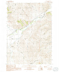
1991 Map of Grouse
USGS Topo · Published 1991About this map
The White Knob Mountains dominate the northern landscape of this Idaho interior, where the high desert floor of the Antelope Valley meets steep canyon walls. In the early 1990s, this area remained largely defined by the Lost River and its seasonal tributaries, such as Antelope Creek and Hooley Creek. The small settlement of Grouse and the Antelope Cem serve as the primary markers of community life in this remote stretch of Custer and Butte Counties. A network of unpaved trails and 4WD tracks, including Antelope Road, threads through the terrain, connecting isolated watering spots like Richardson Spring and Waddoups Spring. The presence of the Antelope Valley Airport near Dry Fork Creek highlights the logistical necessity of air travel in navigating these expansive Idaho ranges.
Find a feature on this map
40 named features on this map. Tap any name to fly to it.
Don’t see what you’re looking for? This feature index may not catch every label — zoom into the map to look around manually.
Map Details
Editions of this 1991 Grouse Map
This is the sole edition of this map. No revisions or reprints were ever made.
Other maps of this area

1935 · MacKay
USGS Topo · 1:96,000

1940 · Mackay
USGS Topo · 1:62,500

1955 · Idaho Falls
USGS Topo · 1:250,000

1958 · Idaho Falls
USGS Topo · 1:250,000

1960 · Grouse
USGS Topo · 1:62,500

1960 · Mackay
USGS Topo · 1:62,500

1969 · Darlington
USGS Topo · 1:24,000

1972 · Nichols Reservoir
USGS Topo · 1:24,000

1972 · Appendicitis Hill
USGS Topo · 1:24,000
1988 · Arco
USGS Topo · 1:100,000