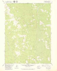
1979 Map of Grouse Mtn
USGS Topo · Published 1979About this map
Six Rivers National Forest dominates this topographic study of the Northern California wilderness, showcasing a landscape defined by steep ridges and isolated outposts. The summit of Horse Mountain serves as a focal point for infrastructure and industry, featuring both the Horse Mountain Radio Towers and the Horse Mountain Mine. The area's settlement pattern is reflected in remote stations and family-named cabins, such as Ammon Station, McMillion Cabin, and the Lower Joe Green Cabin situated near the base of Spike Buck Mountain.
Find a feature on this map
48 named features on this map. Tap any name to fly to it.
Don’t see what you’re looking for? This feature index may not catch every label — zoom into the map to look around manually.
Map Details
Editions of this 1979 Grouse Mtn Map
2 editions found
Other maps of this area

1914 · Pilot Creek
USGS Topo · 1:62,500

1915 · Big Bar and Vicinity
USGS Topo · 1:250,000

1922 · Korbel
USGS Topo · 1:62,500

1922 · China Flat
USGS Topo · 1:62,500

1922 · Kneeland
USGS Topo · 1:62,500

1945 · Blue Lake
USGS Topo · 1:62,500

1950 · Iaqua Buttes
USGS Topo · 1:62,500

1951 · Pilot Creek
USGS Topo · 1:62,500

1951 · Blue Lake
USGS Topo · 1:62,500

1952 · Willow Creek
USGS Topo · 1:62,500