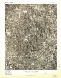
1977 Map of Grovespring
USGS Topo · Published 1977About this map
Grovespring forms the central focal point of this 1977 aerial survey of Wright County, Missouri. Produced as an advance orthophotograph print in cooperation with the Soil Conservation Service, the map provides a precise visual record of the landscape as it appeared in the late 1970s. The imagery reveals the intricate balance between wooded drainage patterns and the rectangular grid of agricultural clearings characteristic of the Ozark Plateau. Researchers can observe the density of rural homesteads and farm structures distributed along the township roads, offering a detailed snapshot of land use and property development before modern expansion. This specific edition is particularly valuable for its clear depiction of the terrain and vegetation coverage during the mid-April spring season.
Find a feature on this map
1 named feature on this map. Tap any name to fly to it.
Don’t see what you’re looking for? This feature index may not catch every label — zoom into the map to look around manually.
Map Details
Editions of this 1977 Grovespring Map
This is the sole edition of this map. No revisions or reprints were ever made.
Other maps of this area

1931 · Manes
USGS Topo · 1:48,000

1941 · Manes
USGS Topo · 1:62,500

1941 · Lebanon
USGS Topo · 1:62,500

1943 · Lebanon
USGS Topo · 1:62,500

1943 · Manes
USGS Topo · 1:62,500

1943 · Drynob
USGS Topo · 1:62,500

1954 · Springfield
USGS Topo · 1:250,000

1954 · Drynob
USGS Topo · 1:62,500

1954 · Drew
USGS Topo · 1:24,000

1956 · Duncan
USGS Topo · 1:24,000