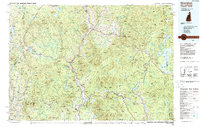
1986 Map of Groveton
USGS Topo · Published 1988About this map
The Connecticut River serves as the primary artery of this mid-1980s survey, marking the border between New Hampshire and Vermont where industry and transit once thrived. In Groveton, the landscape is shaped by the intersection of the Grand Trunk RR and the Boston & Maine RR, reflecting a dense network of mountain logging and regional commerce. This era shows the extensive reach of the White Mountain National Forest alongside state-managed lands like Victory State Forest and Maidstone State Forest. To the east, the rugged topography of the Mahoosuc Range and Dixville Mountains gives way to the expansive waters of Umbagog Lake and the Magalloway River system. The map captures long-established settlements such as North Stratford and Colebrook, while smaller crossroads like Kidderville and Stewartstown Hollow remain visible in the valleys. This study provides a detailed view of the Northern Forest at a time when traditional rail lines still traced the riverbanks and wilderness preservation was firmly established.
Find a feature on this map
164 named features on this map. Tap any name to fly to it.
Don’t see what you’re looking for? This feature index may not catch every label — zoom into the map to look around manually.
Map Details
Editions of this 1986 Groveton Map
2 editions found
Other maps of this area

1893 · Mt. Washington
USGS Topo · 1:62,500

1893 · Gorham
USGS Topo · 1:62,500

1896 · Mt. Washington
USGS Topo · 1:62,500

1896 · Gorham
USGS Topo · 1:62,500

1900 · Whitefield
USGS Topo · 1:62,500

1914 · Bethel
USGS Topo · 1:62,500

1919 · Lake Memphremagog
USGS Topo · 1:62,500

1920 · Derby
USGS Topo · 1:62,500

1920 · Guildhall
USGS Topo · 1:62,500

1923 · Lake Memphremagog
USGS Topo · 1:48,000