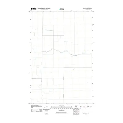
2010 Map of Grygla NE
USGS Topo · Published 2010About this map
Moose River meanders across this rural section of Beltrami County, defining the drainage patterns of an otherwise flat, surveyed landscape in Northern Minnesota. The area is characterized by a geometric grid of rural routes and farm-to-market roads, including County Hwy-1 and County Hwy-54, which facilitate travel between isolated agricultural plots and timber stands. This survey by the U.S. Geological Survey shows the intersection of local infrastructure such as Pine Island Rd NW and 380th St NE, illustrating the persistent township and range system that organized this region. For the researcher, the map documents the late 20th and early 21st-century road network, capturing the connectivity of remote homesteads via routes like County Hwy-133.
Find a feature on this map
9 named features on this map. Tap any name to fly to it.
Don’t see what you’re looking for? This feature index may not catch every label — zoom into the map to look around manually.
Map Details
Editions of this 2010 Grygla NE Map
This is the sole edition of this map. No revisions or reprints were ever made.
Other maps of this area

1918 · Pencer
USGS Topo · 1:62,500

1918 · Malcolm
USGS Topo · 1:62,500

1919 · Liner
USGS Topo · 1:62,500

1954 · Roseau
USGS Topo · 1:250,000

1957 · Roseau
USGS Topo · 1:250,000

1958 · Roseau
USGS Topo · 1:250,000

1968 · Mulligan Lake SW
USGS Topo · 1:24,000
1968 · Wannaska SW
USGS Topo · 1:24,000
1969 · Skime
USGS Topo · 1:24,000
1973 · Grygla
USGS Topo · 1:24,000