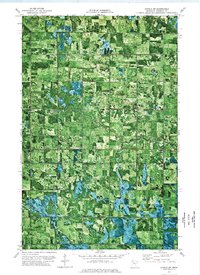
1973 Map of Grygla SW
USGS Topo · Published 1976About this map
The Mud River meanders across this northern Minnesota landscape, carving a winding path through a region defined by its vast wetlands and organized township divisions. This orthophotomap, derived from 1969 aerial photography and 1973 field checks, reveals the distinct grid of rural roads and drainage patterns in the townships of Rollis, Veldt, Valley, Moylan, and Espelie. The settlement of Grygla sits near the eastern edge, serving as a primary hub for this agricultural and conservation-heavy area.
Find a feature on this map
8 named features on this map. Tap any name to fly to it.
Don’t see what you’re looking for? This feature index may not catch every label — zoom into the map to look around manually.
Map Details
Editions of this 1973 Grygla SW Map
This is the sole edition of this map. No revisions or reprints were ever made.
Other maps of this area

1918 · Rollis
USGS Topo · 1:62,500

1919 · Liner
USGS Topo · 1:62,500

1943 · Rollis
USGS Topo · 1:62,500

1954 · Roseau
USGS Topo · 1:250,000

1957 · Roseau
USGS Topo · 1:250,000

1958 · Roseau
USGS Topo · 1:250,000

1962 · Gatzke SE
USGS Topo · 1:24,000

1962 · Gatzke
USGS Topo · 1:24,000
1972 · Goodridge
USGS Topo · 1:24,000
1973 · Grygla
USGS Topo · 1:24,000