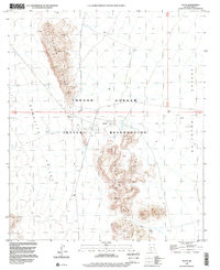
1996 Map of Gu Vo
USGS Topo · Published 2000About this map
The Tohono O'odham Indian Reservation landscape is defined by the prominent Gu Vo Hills, which divide the terrain into distinct desert basins. This 1996 survey illustrates a sparsely populated region of Pima County where life centers on water sources and traditional settlements. The village of Gu Vo is located near the central gap in the hills, serving as a primary point of habitation alongside the smaller settlement of Pia to the south.
Find a feature on this map
14 named features on this map. Tap any name to fly to it.
Don’t see what you’re looking for? This feature index may not catch every label — zoom into the map to look around manually.
Map Details
Editions of this 1996 Gu Vo Map
This is the sole edition of this map. No revisions or reprints were ever made.
Other maps of this area

1953 · Ajo
USGS Topo · 1:250,000

1954 · Sonoyta
USGS Topo · 1:250,000

1957 · Ajo
USGS Topo · 1:250,000

1958 · Ajo
USGS Topo · 1:250,000

1962 · Ajo
USGS Topo · 1:250,000

1963 · Ajo
USGS Topo · 1:250,000

1963 · Kom Vo
USGS Topo · 1:62,500

1963 · Mt. Ajo
USGS Topo · 1:62,500

1963 · Pisinimo
USGS Topo · 1:62,500

1963 · Lukeville
USGS Topo · 1:250,000