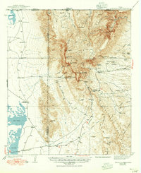
1940 Map of Guadalupe Peak
USGS Topo · Published 1949About this map
Guadalupe Peak Highest Point in Texas anchors this 1930s survey, rising sharply above the Crow Flats and the western Salt Lake. The map reveals a landscape defined by isolated ranching outposts and rugged canyons before the area's later designation as a national park. Trace the distribution of essential water sources like Choza Spring, Bone Spring, and Manzanita Spring, which supported human habitation in this arid terrain. Remote residential and commercial sites, including Pratt Lodge, Frijole, and the Williams Ranch, are connected by the primitive precursor to U.S. 62 180. The presence of an Airway Beacon and a Filling Sta at Pine Spring Camp signals the slow encroachment of modern transportation infrastructure into the Trans-Pecos wilderness during the pre-war era.
Find a feature on this map
85 named features on this map. Tap any name to fly to it.
Don’t see what you’re looking for? This feature index may not catch every label — zoom into the map to look around manually.
Map Details
Editions of this 1940 Guadalupe Peak Map
2 editions found
Other maps of this area

1933 · Guadalupe Peak
USGS Topo · 1:48,000

1935 · El Paso Gap
USGS Topo · 1:62,500

1936 · El Paso Gap
USGS Topo · 1:48,000

1940 · El Paso Gap
USGS Topo · 1:62,500

1940 · Guadalupe Peak
USGS Topo · 1:62,500

1940 · Carlsbad Caverns West
USGS Topo · 1:62,500

1943 · Carlsbad Caverns West
USGS Topo · 1:62,500

1951 · Dell City
USGS Topo · 1:62,500

1954 · Carlsbad
USGS Topo · 1:250,000

1954 · Van Horn
USGS Topo · 1:250,000