1947 Map of Guayama NO
USGS Topo · Published 1947About this map
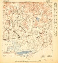
Guayama anchors this coastal survey, revealing a landscape defined by industrial agriculture and the transition from mountain foothills to the Mar Caribe. The region is densely populated with agricultural settlements known as colonias and haciendas, including Colonia Vives, Hacienda Carlota, and Colonia Algarrobo, which supported the sugar economy centered around Central Machete. These settlements follow the natural water sources of the Canal de Guamani Oeste and Quebrada Corazón.
Find a feature on this map
22 named features on this map. Tap any name to fly to it.
Don’t see what you’re looking for? This feature index may not catch every label — zoom into the map to look around manually.
Map Details
Editions of this 1947 Guayama NO Map
This is the sole edition of this map. No revisions or reprints were ever made.
Historical Maps of Las Guásimas Through Time
5 maps found