
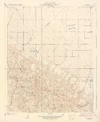
1933 Map of Guijarral Hills
USGS Topo · Published 1933About this map
Industrial infrastructure and ranching define this Fresno County landscape during the early 1930s. The northern portion of the quadrangle is dominated by an extensive Oil Tank Farm and the Caloila Pumping Sta, highlighting the region's importance to the California petroleum industry. Further south, the settlement of Turk sits along the Southern Pacific (Coalinga Branch) railroad, which runs parallel to a major Corporation Power Line.
Find a feature on this map
11 named features on this map. Tap any name to fly to it.
Don’t see what you’re looking for? This feature index may not catch every label — zoom into the map to look around manually.
Map Details
Editions of this 1933 Guijarral Hills Map
This is the sole edition of this map. No revisions or reprints were ever made.
Other maps of this area

1912 · Coalinga
USGS Topo · 1:125,000

1928 · Delta Farms No 3
USGS Topo · 1:31,680

1930 · Discovery Well
USGS Topo · 1:31,680

1930 · Canoas Creek
USGS Topo · 1:31,680

1932 · Delta Farms
USGS Topo · 1:31,680

1932 · West of Lethent
USGS Topo · 1:31,680

1933 · Huron
USGS Topo · 1:31,680
1934 · La Cima
USGS Topo · 1:31,680

1934 · Canoas Creek
USGS Topo · 1:31,680

1936 · Kreyenhagen Hills
USGS Topo · 1:31,680