
1930 Map of Canoas Creek
USGS Topo · Published 1930About this map
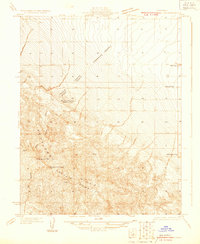
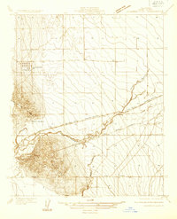
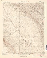
Kettleman Hills (North Dome) dominates this central California landscape at a pivotal moment in the region's energy history. Surveyed just two years after the 1928 discovery of oil in the area, the map records the early development of the Avenal settlement and the critical Discovery Well that triggered the local boom. The terrain is defined by the sharp ridges of the Kreyenhagen Hills and the seasonal drainages of Zapato Creek and Canoas Creek. A prominent diagonal path across the valley floor, the Coalinga and Bakersfield Road, serves as the primary artery for transportation and industry. The topography clearly shows the Polvadero Gap to the north, a natural break in the hills that shaped the movement of both water and early infrastructure. This survey captures the transition from a sparse grazing landscape to a concentrated petroleum district along the Fresno Kings county line.
Find a feature on this map
10 named features on this map. Tap any name to fly to it.
Don’t see what you’re looking for? This feature index may not catch every label — zoom into the map to look around manually.
Map Details
Editions of this 1930 Canoas Creek Map
This is the sole edition of this map. No revisions or reprints were ever made.
Other maps of this area

1912 · Coalinga
USGS Topo · 1:125,000

1914 · Cholame
USGS Topo · 1:125,000

1915 · Cholame
USGS Topo · 1:125,000

1917 · Cholame
USGS Topo · 1:125,000
1930 · Discovery Well
USGS Topo · 1:31,680

1930 · Kettleman Plain
USGS Topo · 1:31,680

1933 · Huron
USGS Topo · 1:31,680
1933 · Guijarral Hills
USGS Topo · 1:31,680
1933 · Kettleman Plain
USGS Topo · 1:31,680
1934 · The Dark Hole
USGS Topo · 1:31,680