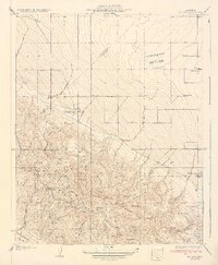
1934 Map of La Cima
USGS Topo · Published 1934About this map
Kettleman North Dome and the surrounding Kettleman Plain define this landscape during the mid-1930s oil boom in Kings County. The map documents a critical era of industrial expansion, centered on petroleum extraction and early energy infrastructure. Central to this development is the Discovery Well, situated near the Standard Oil Camp, illustrating the transition of the region into a major energy-producing hub. The presence of the Pacific Gas and Electric Plant further underscores the area's industrial importance during this period.
Find a feature on this map
48 named features on this map. Tap any name to fly to it.
Don’t see what you’re looking for? This feature index may not catch every label — zoom into the map to look around manually.
Map Details
Editions of this 1934 La Cima Map
2 editions found
Other maps of this area

1912 · Coalinga
USGS Topo · 1:125,000

1914 · Lost Hills
USGS Topo · 1:125,000

1914 · Cholame
USGS Topo · 1:125,000

1915 · Cholame
USGS Topo · 1:125,000

1917 · Cholame
USGS Topo · 1:125,000

1929 · Westhaven
USGS Topo · 1:31,680

1930 · Discovery Well
USGS Topo · 1:31,680

1930 · Canoas Creek
USGS Topo · 1:31,680

1930 · Kettleman Plain
USGS Topo · 1:31,680

1930 · Middle Dome
USGS Topo · 1:31,680