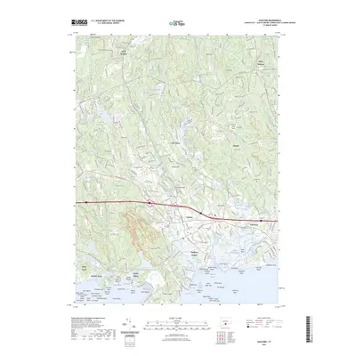
2023 Map of Guilford
USGS Topo · Published 2023About this map
Guilford and its surrounding coastline reveal a intricate network of tidal marshes and glacial landforms along Long Island Sound. The town center is flanked by significant local water bodies such as the Town Millpond and Witch Hazel Millpond, illustrating a legacy of early water-powered industry. To the north, the landscape transitions from the coastal lowlands of Guilford Center to the elevations of Race Hill and Walnut Hill, punctuated by numerous reservoirs like Guilford Lake and West Lake. Genealogy researchers can locate several established burial grounds across the area, including Old Guilford North Cem and Alderbrook Cem. The map clearly shows the fragmented shoreline of Leetes Island and the prominent granite outcrops of Sachem Head, while the eastern boundary is defined by the meandering course of the East River. Inland, the Podunk Great Plain provides a distinct contrast to the more varied terrain of Hungry Hill and Prospect Hill.
Find a feature on this map
117 named features on this map. Tap any name to fly to it.
Don’t see what you’re looking for? This feature index may not catch every label — zoom into the map to look around manually.
Map Details
Editions of this 2023 Guilford Map
This is the sole edition of this map. No revisions or reprints were ever made.
Other maps of this area

1892 · New Haven
USGS Topo · 1:62,500

1893 · Guilford
USGS Topo · 1:62,500

1921 · New Haven
USGS Topo · 1:62,500

1943 · Durham
USGS Topo · 1:25,000

1947 · Hartford
USGS Topo · 1:250,000

1948 · Hartford
USGS Topo · 1:250,000

1951 · Clinton
USGS Topo · 1:31,680

1952 · Haddam
USGS Topo · 1:31,680

1953 · Durham
USGS Topo · 1:31,680

1954 · Guilford
USGS Topo · 1:31,680