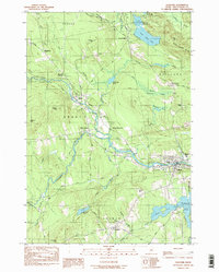
1984 Map of Guilford
USGS Topo · Published 1984About this map
The Piscataquis River and its major tributaries, Kingsbury Stream and Carlton Stream, dictate the development of this Piscataquis County landscape. The industrial and residential center of Guilford anchors the eastern edge of the map, while the smaller hamlets of Abbot Village and Monson Junction are positioned at critical rail and river points to the west. Evidence of the region’s mid-20th-century educational and civic infrastructure is visible through the Piscataquis Comm High Sch and the McKusick Sch in Parkman.
Find a feature on this map
64 named features on this map. Tap any name to fly to it.
Don’t see what you’re looking for? This feature index may not catch every label — zoom into the map to look around manually.
Map Details
Editions of this 1984 Guilford Map
2 editions found
Other maps of this area

1933 · Guilford
USGS Topo · 1:62,500

1937 · Guilford
USGS Topo · 1:62,500

1948 · Kingsbury
USGS Topo · 1:62,500

1950 · Kingsbury
USGS Topo · 1:62,500

1950 · Sebec Lake
USGS Topo · 1:62,500

1951 · Greenville
USGS Topo · 1:62,500

1954 · Millinocket
USGS Topo · 1:250,000

1958 · Millinocket
USGS Topo · 1:250,000

1960 · Millinocket
USGS Topo · 1:250,000

1975 · Kingsbury NE
USGS Topo · 1:24,000