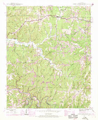
1946 Map of Guinn Cross Roads
USGS Topo · Published 1970About this map
Little Bear Creek winds through this section of Franklin County, showing the landscape just as the Tennessee Valley Authority was planning major hydrological changes. The inclusion of the Little Bear Creek Dam (proposed) near Piney Bend marks a significant transition point for the valley, predating the full implementation of the reservoirs that would later alter these creek banks. Small upland settlements like Guinn Cross Roads, Old Nauvoo, and Dempsey serve as the primary anchors for a rural community connected by a network of winding roads such as Sartin Mill.
Find a feature on this map
73 named features on this map. Tap any name to fly to it.
Don’t see what you’re looking for? This feature index may not catch every label — zoom into the map to look around manually.
Map Details
Editions of this 1946 Guinn Cross Roads Map
This is the sole edition of this map. No revisions or reprints were ever made.
Other maps of this area

1925 · Barton
USGS Topo · 1:62,500

1926 · Barton
USGS Topo · 1:48,000

1929 · Barton
USGS Topo · 1:62,500

1935 · Pleasant Site
USGS Topo · 1:24,000

1936 · Frankfort
USGS Topo · 1:24,000

1936 · Pleasant Grove
USGS Topo · 1:24,000

1936 · Hodges
USGS Topo · 1:24,000

1936 · Isbell
USGS Topo · 1:24,000

1936 · Hackleburg
USGS Topo · 1:24,000

1936 · Vina
USGS Topo · 1:24,000