
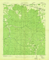
1936 Map of Frankfort
USGS Topo · Published 1936About this map
The Chickasaw Boundary cuts across this 1936 survey of the Alabama uplands, marking a historic line of demarcation between Colbert and Franklin counties. The settlement of Frankfort serves as a local hub, surrounded by a landscape defined by small-scale agrarian infrastructure and family-named landmarks. The presence of Hovaters Mill on Jackson Mill Creek indicates the continued importance of local milling sites for the surrounding farmsteads during the mid-1930s. Rural education and faith are central to the map's geography, with several community nodes such as Cedar Creek Sch, Mt Zion Sch, and Shady Grove Ch distributed along the winding creek branches. Genealogists will find significant value in the numerous small burial grounds, including Burnt Church Cem, Antioch Cem, and Taylor Cem, which anchor family histories to specific ridges and hollows.
Find a feature on this map
41 named features on this map. Tap any name to fly to it.
Don’t see what you’re looking for? This feature index may not catch every label — zoom into the map to look around manually.
Map Details
Editions of this 1936 Frankfort Map
This is the sole edition of this map. No revisions or reprints were ever made.
Other maps of this area

1924 · Tuscumbia
USGS Topo · 1:48,000

1925 · Barton
USGS Topo · 1:62,500

1926 · Tuscumbia
USGS Topo · 1:62,500

1926 · Barton
USGS Topo · 1:48,000

1929 · Barton
USGS Topo · 1:62,500

1936 · Russellville
USGS Topo · 1:24,000

1936 · Pleasant Grove
USGS Topo · 1:24,000

1936 · Isbell
USGS Topo · 1:24,000

1936 · Pride
USGS Topo · 1:24,000
1936 · Barton
USGS Topo · 1:24,000