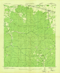
1936 Map of Barton
USGS Topo · Published 1936About this map
Barton sits at the northern edge of this 1936 field examination, where the Southern Railway and Southern Highway No 72 parallel the Tennessee Valley Authority transmission lines. The landscape to the south transitions into the high ground of Sand Mountain and Mills Ridge, a territory defined by deep hollows and numerous springs that supported early 20th-century rural life. The presence of multiple burial grounds, including the New Newsom Spring Cem and Old Newsom Spring Cem near Newsom Spring Sch, suggests a community deeply rooted in the local geography of Sanderson Hollow and Buzzard Roost Creek. To the west, the isolated Mt Zion Ch and Stuarts Camp mark the pockets of settlement tucked between drainage systems like Asphalt Creek and Hamilton Creek, providing a detailed look at Colbert County before modern infrastructure reshaped these uplands.
Find a feature on this map
59 named features on this map. Tap any name to fly to it.
Don’t see what you’re looking for? This feature index may not catch every label — zoom into the map to look around manually.
Map Details
Editions of this 1936 Barton Map
This is the sole edition of this map. No revisions or reprints were ever made.
Other maps of this area

1911 · Iuka
USGS Topo · 1:48,000

1914 · Iuka
USGS Topo · 1:62,500

1924 · Gravelly Springs
USGS Topo · 1:48,000

1925 · Barton
USGS Topo · 1:62,500

1926 · Barton
USGS Topo · 1:48,000

1926 · Gravelly Springs
USGS Topo · 1:62,500

1929 · Barton
USGS Topo · 1:62,500

1935 · Cherokee
USGS Topo · 1:24,000

1935 · Pleasant Site
USGS Topo · 1:24,000

1936 · Margerum
USGS Topo · 1:24,000