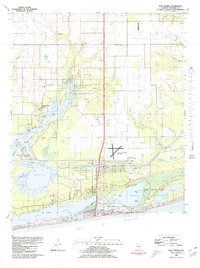
1980 Map of Gulf Shores
USGS Topo · Published 1980About this map
Gulf State Park dominates the southeastern coastline of this 1980 survey, where the barrier landscape is defined by Little Lagoon and a series of freshwater lakes like Shelby Is. This period shows the coastal community of Gulf Shores during a transition of significant infrastructure development. The Intracoastal Waterway cuts a straight path through the salt marshes, facilitating maritime commerce and recreation between Oyster Bay and the surrounding bayous. To the north, the settlement of Bon Secour maintains its connection to the water via the Bon Secour River and Swift Landing. The presence of numerous extractive sites, such as various claypits and sandpits, alongside the newly established Jack Edwards Airport, indicates a landscape being actively reshaped. Local history is anchored by several rural landmarks, including Swift Sch and several country churches like Pleasant View Ch and Friendship Ch.
Find a feature on this map
45 named features on this map. Tap any name to fly to it.
Don’t see what you’re looking for? This feature index may not catch every label — zoom into the map to look around manually.
Map Details
Editions of this 1980 Gulf Shores Map
2 editions found
Other maps of this area

1921 · Bon Secour
USGS Topo · 1:62,500

1921 · Point Clear
USGS Topo · 1:62,500

1941 · Foley
USGS Topo · 1:62,500

1941 · Weeks Bay
USGS Topo · 1:62,500

1943 · Weeks Bay
USGS Topo · 1:62,500

1943 · Foley
USGS Topo · 1:62,500

1944 · Miflin
USGS Topo · 1:25,000

1957 · Pensacola
USGS Topo · 1:250,000

1959 · Pensacola
USGS Topo · 1:250,000

1960 · Pensacola
USGS Topo · 1:250,000