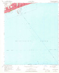
1954 Map of Gulfport South
USGS Topo · Published 1965About this map
Gulfport and its waterfront neighborhoods like Gaston Point are depicted during a period of significant mid-century development along the Mississippi coast. This maritime-focused survey highlights the critical infrastructure of the era, from the Louisville and Nashville Railroad corridor to the industrial activity at Gulfport Harbor. The map provides a detailed view of the city's civic and healthcare landscape, featuring Memorial Hospital and multiple Junior High and High Schools.
Find a feature on this map
27 named features on this map. Tap any name to fly to it.
Don’t see what you’re looking for? This feature index may not catch every label — zoom into the map to look around manually.
Map Details
Editions of this 1954 Gulfport South Map
4 editions found
Other maps of this area

1893 · Cat Island
USGS Topo · 1:62,500

1946 · Isle Au Pitre
USGS Topo · 1:31,680

1950 · Ship Island
USGS Topo · 1:24,000

1951 · Cat Island
USGS Topo · 1:24,000

1953 · Mobile
USGS Topo · 1:250,000

1954 · Isle Au Pitre
USGS Topo · 1:31,680

1954 · Gulfport North
USGS Topo · 1:24,000

1954 · Gulfport South
USGS Topo · 1:24,000

1954 · Biloxi
USGS Topo · 1:24,000

1954 · Biloxi
USGS Topo · 1:62,500