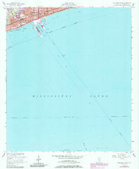
1954 Map of Gulfport South
USGS Topo · Published 1985About this map
Gulfport serves as a critical maritime hub in this mid-century look at the Mississippi coast, where the deep-water Gulfport Channel cuts a straight line through the Mississippi Sound to reach the mainland. The urban waterfront is defined by the extensive Gulfport Harbor, protected by long piers and bulkheads, and the sprawling U S Naval Reservation just west of Gaston Point. This 1954 survey, later updated with purple-tinted urban extensions in 1985, illustrates the intersection of rail and sea commerce along the Louisville and Nashville Railroad corridor. Further south, the map details the transition from the Intracoastal Waterway into the shoals and spits of Cat Island, including North Point and the shifting sands of Raccoon Spit. It provides a clear view of the harbor's infrastructure before decades of modern coastal development altered the shoreline profile.
Find a feature on this map
28 named features on this map. Tap any name to fly to it.
Don’t see what you’re looking for? This feature index may not catch every label — zoom into the map to look around manually.
Map Details
Editions of this 1954 Gulfport South Map
4 editions found
Other maps of this area

1893 · Cat Island
USGS Topo · 1:62,500

1946 · Isle Au Pitre
USGS Topo · 1:31,680

1950 · Ship Island
USGS Topo · 1:24,000

1951 · Cat Island
USGS Topo · 1:24,000

1953 · Mobile
USGS Topo · 1:250,000

1954 · Isle Au Pitre
USGS Topo · 1:31,680

1954 · Gulfport North
USGS Topo · 1:24,000

1954 · Gulfport South
USGS Topo · 1:24,000

1954 · Biloxi
USGS Topo · 1:24,000

1954 · Biloxi
USGS Topo · 1:62,500