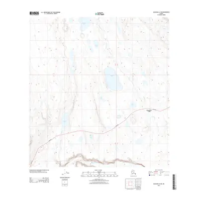
2013 Map of Gulkana A-6 SE
USGS Topo · Published 2013About this map
Mendeltna Lodge serves as the primary landmark in this interior Alaskan landscape, situated along the corridor of the Glenn Hwy. The region is defined by a complex network of glacial lakes and slow-moving drainages, including the prominent Snowshoe Lake and Nickoli Lake. The southern edge of the sheet follows the meandering course of the Nelchina River, while the northern terrain is punctuated by smaller water bodies such as Old Man Lake and Tawawe Lake. This 2013 topographic survey captures the sparsely settled character of the Unorganized Borough, where human activity is largely concentrated near the highway. Numerous unnamed tributaries and seasonal wetlands feed into named channels like Mendeltna Cr and Cache Cr, illustrating the seasonal water patterns typical of the Copper River Basin's western reaches.
Find a feature on this map
13 named features on this map. Tap any name to fly to it.
Don’t see what you’re looking for? This feature index may not catch every label — zoom into the map to look around manually.
Map Details
Editions of this 2013 Gulkana A-6 SE Map
This is the sole edition of this map. No revisions or reprints were ever made.
Other maps of this area

1949 · Gulkana A-5
USGS Topo · 1:63,360

1949 · Gulkana A-6
USGS Topo · 1:63,360

1949 · Valdez D-8
USGS Topo · 1:63,360

1949 · Valdez D-7
USGS Topo · 1:63,360

1951 · Gulkana
USGS Topo · 1:250,000

1951 · Valdez D-7
USGS Topo · 1:63,360

1952 · Valdez D-8
USGS Topo · 1:63,360

1952 · Valdez
USGS Topo · 1:250,000

1952 · Gulkana A-5
USGS Topo · 1:63,360
1952 · Gulkana A-6
USGS Topo · 1:63,360