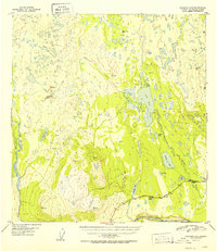
1952 Map of Gulkana A-6
USGS Topo · Published 1952About this map
Mendeltna Lodge and Ryan Lodge stand as early outposts of settlement along the Glenn Highway in this mid-century survey of the Alaska interior. The landscape is defined by an intricate network of waterways, including Old Man Lake, Nickoli Lake, and the meandering path of Mendeltna Creek. These features illustrate the Importance of seasonal access and water resources in the era before widespread road development.
Find a feature on this map
26 named features on this map. Tap any name to fly to it.
Don’t see what you’re looking for? This feature index may not catch every label — zoom into the map to look around manually.
Map Details
Editions of this 1952 Gulkana A-6 Map
2 editions found
Other maps of this area

1948 · Anchorage D-1
USGS Topo · 1:63,360

1949 · Gulkana A-5
USGS Topo · 1:63,360

1949 · Talkeetna Mountains A-1
USGS Topo · 1:63,360

1949 · Gulkana A-6
USGS Topo · 1:63,360

1949 · Valdez D-8
USGS Topo · 1:63,360

1949 · Valdez D-7
USGS Topo · 1:63,360

1950 · Talkeetna Mountains
USGS Topo · 1:250,000

1950 · Gulkana B-6
USGS Topo · 1:63,360

1951 · Gulkana
USGS Topo · 1:250,000

1951 · Valdez D-7
USGS Topo · 1:63,360